
Difficulty: BEGINNER
Time: 3-5 HOURS
Distance: 8 MILES
Elevation Gain: 1500 Feet
Foot Traffic: MODERATE
Challenges: Muddy, Several possible routes to take, Buggy
Sights: Honolulu, Bamboo Forest, Ko'olau Range
What to Bring: Water (>1L) Snack, Bug Spray
A more traditional hike, this hike takes place along the Mauka Trail system up in Mount Tantalus. The Makiki Tantalus loop covers a large portion of this trail system, hitting many of the highlights. Along the way, you will see beautiful plants and trees, a bamboo forest, and some great vantage points of the Ko'olau Mountain Range and neighboring valleys. While you won't get those expansive views from your typical ungraded ridge, this trail is a great way to get you hiking in a different, but equally beautiful part of Hawaii.
After a month and half away, we're finally back! Where did that time go? I will say March Madness stole some of that time that I'd normally be hiking (totally worth it though, UVA National Champions WAHOOWAII). Anyway, it's good to be back on the trails. I decided to take to the Mauka Trail system up in Mount Tantalus to tackle the Makiki Tantalus Loop, as described in Stuart Ball's Hiking Guide to Oahu (well actually completely in reverse). It was a trail to get back into the hiking game

The loop looks something like this (a VERY rough sketch). There are many different paths you can take, so I definitely recommend having this map handy. But I think our intended path does a good job at getting you to all the different vantage points.

Our hike began in the Makiki Valley State Recreation Park. There is a dirt parking lot, but it does fill up. After that, most people will park off the side of the road. Our journey starts along this set of stairs at the back of the parking lot on the Makiki Aboretum Trail.

And that's about it, this trail is like 5 minutes long. It's just a path to get you to the main trails of the Mauka Trail System. Head for those buildings over there, which is the Hawaii Nature Center (they even have bathrooms!).

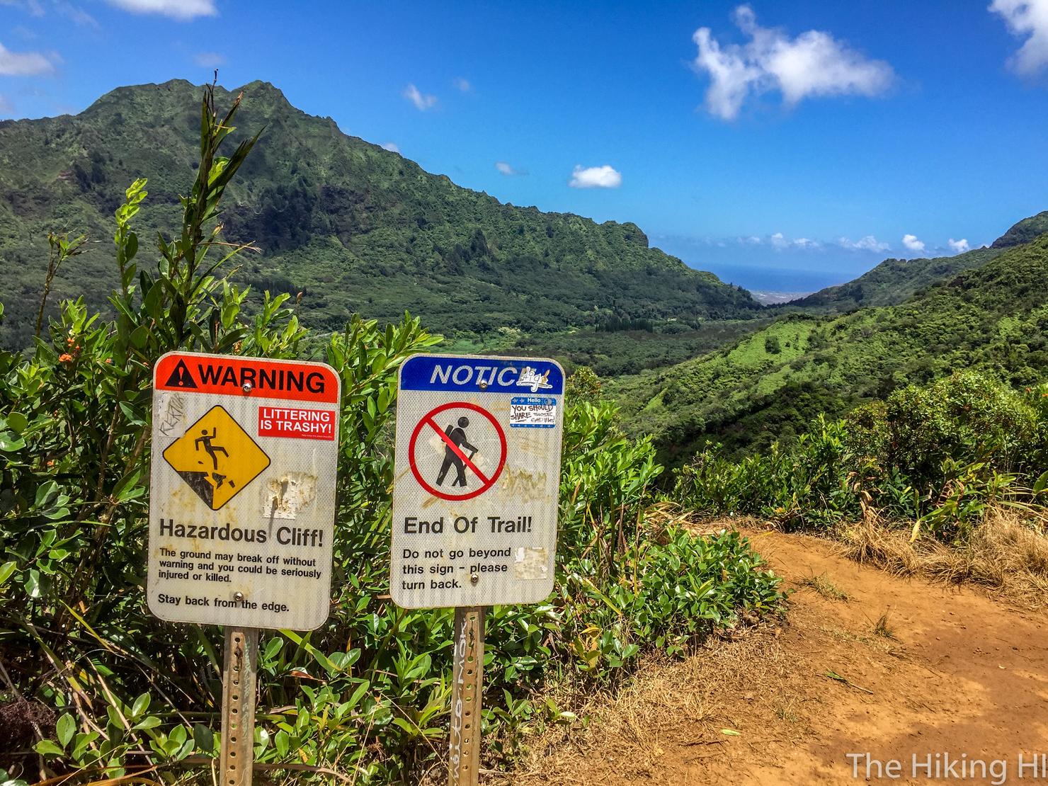
Here you will arrive at the trail information center. Is that what these things are are called? It is so rare to see something like this I don't even know the name. But it does have all the information you would need for the hike.
Looking at the map, our plan was to take the (3) Maunalaha Trail to (7) Moleka Trail to (8) Manoa Cliff Trail to (10) Pauao Flats Trail which ends at a lookout overlooking the Pali Highway. We would then return along (10) Pauoa Flats to (18) Kalawahine Trial to (4) Nahuina Trail to (2) Kanealole Trail to the start. Did you get all that? If not, it's fine because this trail is reasonably trafficked, so there's always someone around to ask. It is also very well marked, as each junction has a sign. And if you do happen to get lost... oh well it's a pretty place for it.

Already getting some of those massive trees right off the bat.

Roughly 15 minutes into Maunalaha is the most physically demanding part of this entire. It's a long gradual uphill on a tree root covered ridge. And unfortunately, when we went, it was midday with zero breeze, so that Hawaii heat and humidity was getting to us.

But it's easy to forget the difficulty with those beautiful surroundings.

There's something so captivating about these trees. It is as if they are guiding you to walk deeper and deeper into their beautiful clutches.

Which of course we will oblige.

After 30ish minutes, we hit this 4 way junction. We will be taking the right path towards the Moleka Trail.

Which shortly after requires a left to actually get on the Moleka Trail. Like I said, every junction is marked, you just have to keep your eye out for it.

This path is where you will get your first views of the hike. On the left side the trees will open up, giving you a glimpse of the valley and towards the western part of the island. Hard to see in this picture, but you are actually looking at the famous Pearl Harbor.

Next up, bamboo! You will run into a few of these on this hike, each forest as grand and beautiful as the next.

Eventually, the Moleka Trail will end on Round Top Drive. Cross the road, and towards the sign on the other side of the road. We now begin (8) the Manoa Cliff Trail, the longest leg of the hike.

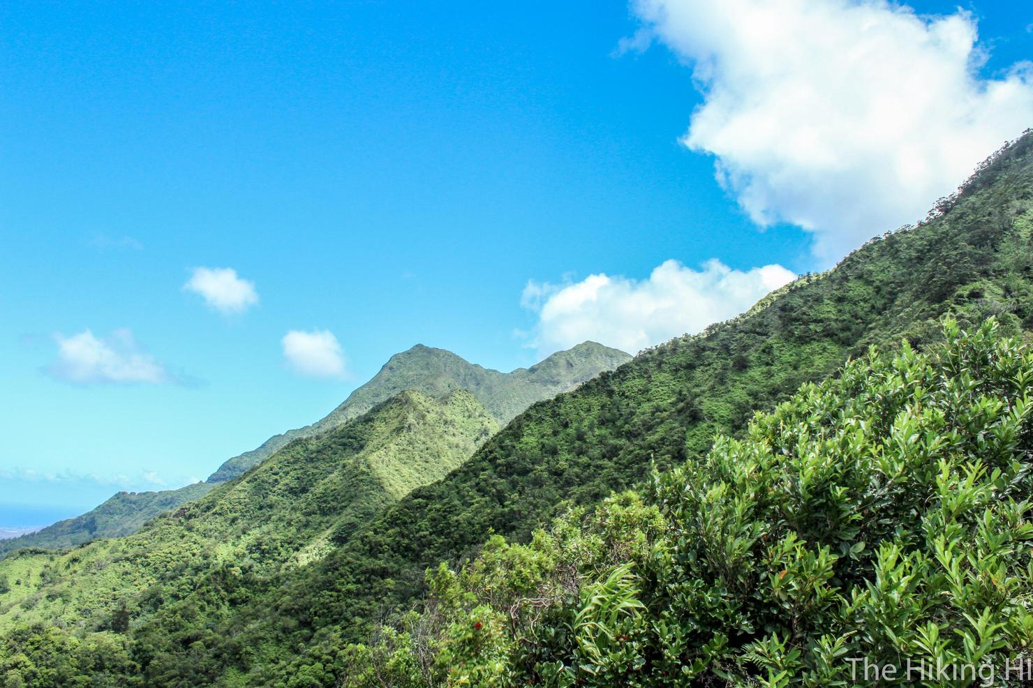
It may be the longest, but it is very scenic. You get an expansive view of those jagged peaks of the Ko'olau Range. While I do like crystal clear skies, the way those clouds rest right on the peaks is quite a sight.

And soon we got a nice look of the famous Diamond Head Crater. I told you, there's a little bit of everything on this trail.

And even a place to sit to take it all in.

Hey, I see the Windward side!

As you continue weaving through the trail, you will see another sign for Pu'u Ohia. To continue on the Tantalus Loop, don't follow this sign. Instead, continue along the trail to the right.

And soon you will arrive at a gate. Don't worry, it isn't locked (although it did say something about feral pigs..). Open and enter.

And soon you will pop out the other side. This is the intersection of the Manoa Cliff Trail and the Pauoa Flats Trail. To continue the Makiki Loop, you should continue straight down Pauoa Flats. Unfortunately for me and Indre, we were getting poured on, so we decided to cut this one short.

But luckily, I frequent these trails to do some running, so I got plenty of pics!

After walking on Pauoa Flats you will come to this plank section. I don't know why these are here, but it sure is nice not getting the shoes muddy. I will say that some of these planks are a bit unstable, so tread lightly. This sign marks a three way junction with the Kalawahine Trail. Continue straight on the Pauoa Flats trail to reach the lookout.

As you continue along Pauoa Flats you will see a couple offshoot trails. These trails offer their own unique experiences and scenery, but are not a part of this "official" Makiki Tantalus Loop. Nu'uanu Trail is commonly combined with Judd Trail in the Nu'uanu Judd Loop.

And Aihualama Trail will actually take you all the way down to the base of the touristy Manoa Falls. A much longer route to get there, but it beats dealing with the crowds.

But we will stay the course on Pauao. Another bamboo forest!
Soon, you will reach the overlook. This is an awesome vantage point of the Pali Highway and the Ko'olaus. If you know where to look, you can spot Pali Puka and the Pali Notches, two short and spectacular ridge hikes.
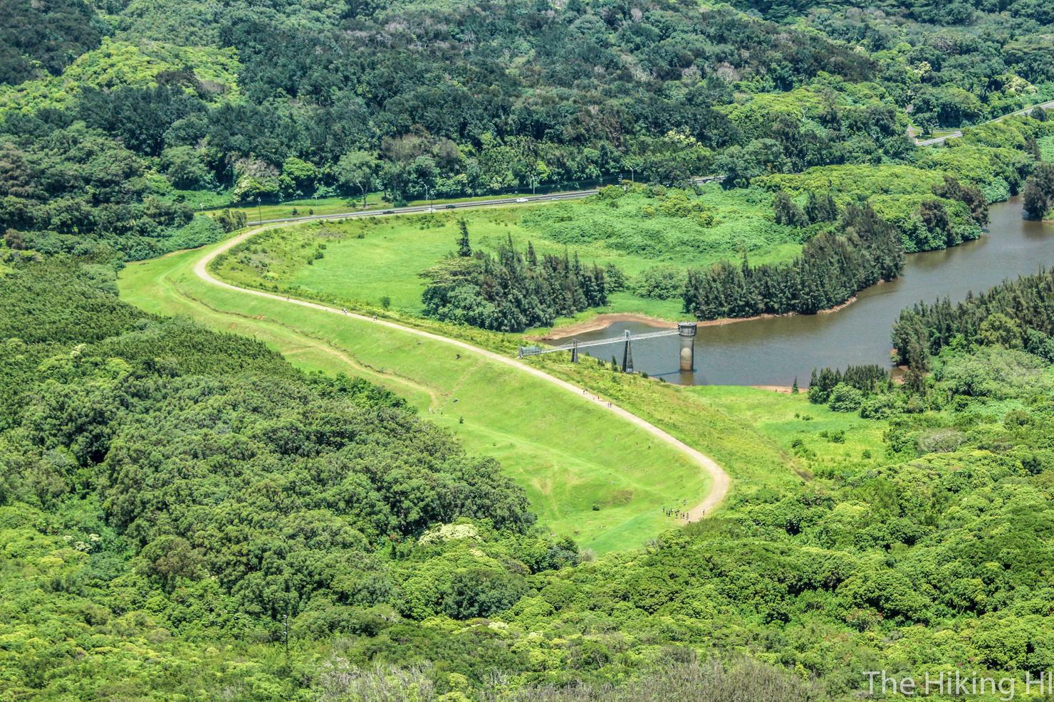
And down in the valley, you can see this long path that ultimately leads to the trail of Lulumahu Falls. At the time of writing this, that trail is not accessible. There was actually a massive landslide on the Pali Highway that led to its closure to all traffic (excepting one way rush hour traffic on weekdays). So as of now, there is no way to get to this trail.
And way up in the distance, you can see Konahuinui 1 and 2 (K1 and K2), the highest peaks in the Ko'olaus. For the extremely ambitious, you can continue along this ridge all the way there.

But we will save that for another day. To complete the loop, backtrack along Pauoa Flats until you reach the 3 way junction on the planks. Head RIGHT on the Kalawahine Trail.

Continue along Kalawahine Trail until it intersects with the road. (Fun fact: this trail used to be known as the Manoa Cliff Trail as well. The online map shows the new name change, but many of the maps physically on the trail do not reflect that).

After you reach the road, head right along the road for a few minutes. On the left side of the road, you will see the entrance to Nahuina.

And 20-30 minutes minutes you will intersect again with Kanealole. From here, we followed the path all the way back.

While we decided to follow the trail outlined by Stuart Ball, there's no set way to hike in Makiki Tantalus. With all the different paths, it really is a choose your own adventure. Whether you are hiking, trail running, walking your dog or just meandering, getting up here and enjoying this unique perspective of the island is what it's all about.